
In the complex world of property development and landscape management, the most significant constraints are often those we cannot see. While the canopy of a tree is easily mapped, the architecture of its root system remains a mystery until a professional intervention takes place. Root location surveys have become a cornerstone of responsible construction, providing the empirical data required to satisfy both structural engineers and local planning authorities. By moving away from theoretical models and toward real-world mapping, developers can maximise their building footprints while ensuring the long-term survival of valuable green assets. This technical deep dive explores how precise subterranean data transforms the design process from a series of assumptions into a verified strategy.
Moving Beyond the Theoretical: The Need for Real Data
For decades, the standard approach to managing trees on construction sites relied on the mathematical formulas provided by British Standards. While the Root Protection Area (RPA) calculation offers a helpful baseline, it is essentially a “best guess” based on the diameter of the tree stem. In reality, roots do not grow in perfect circles: they follow the path of least resistance, seeking out moisture, oxygen, and nutrients. Root location surveys are designed to replace these theoretical circles with actual, physical evidence of root distribution. This is particularly vital in urban environments where pavements, old foundations, and utility trenches have already dictated where a tree can and cannot grow.
When an architect is working on a tight site, every centimetre counts. Relying solely on a circular RPA might lead to a design that unnecessarily avoids “empty” ground or, conversely, places a foundation directly over a critical structural root. By commissioning a detailed survey, the design team gains the freedom to build with confidence. They can identify exactly where roots are absent, allowing for the placement of piles, service runs, or foundations in areas that were previously thought to be off-limits. This level of precision is often the key to unlocking a site’s true potential without compromising its environmental integrity.
Furthermore, the data provided by these surveys is invaluable during the planning application process. Local authority tree officers are increasingly demanding more than just a standard BS5837 report for high-impact developments. They want to see that the applicant has done their due diligence. A formal root map provides a defensible evidence base that can overcome objections and streamline the path to approval. It demonstrates a level of professional rigour that gives the council confidence in the proposed mitigation measures. In short, accurate data is the most effective tool for resolving conflicts between the built and natural environments.

The Technology of Non-Invasive Air Spade Exploration
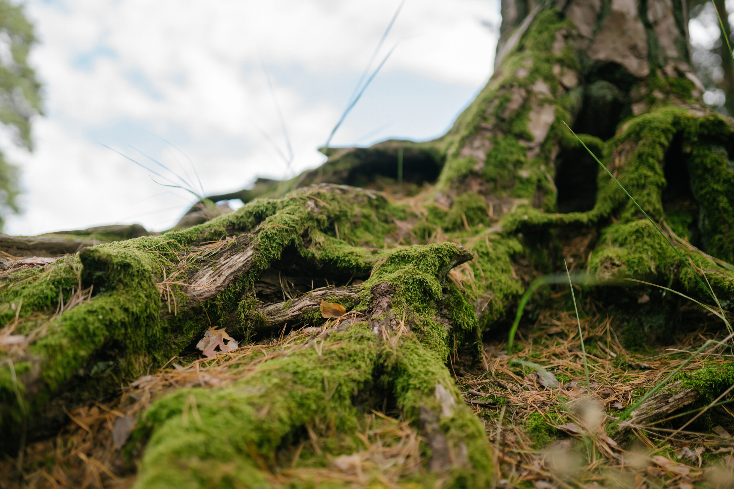
The primary tool used in modern Root location surveys is the air spade, a piece of equipment that has revolutionised arboricultural consultancy. Traditional excavation methods using shovels or backhoes are notoriously destructive, as they can easily sever the very roots that need to be protected. The air spade, however, uses a high-velocity stream of compressed air to dislodge soil while leaving non-porous objects like roots and utility pipes completely unharmed. This non-invasive approach allows for the total exposure of the root system, providing a clear view of the depth, diameter, and health of the underground structures.
The process begins with the careful removal of the upper layers of turf or mulch. Once the soil is reached, the arborist uses the air spade to create narrow “trial trenches” or to clear a larger area around the base of the tree. As the soil is blown away, the roots are revealed in their natural state. This allows the consultant to distinguish between fine “feeder” roots and the larger “structural” roots that provide the tree with its stability. Each significant root can then be measured and plotted using GPS or laser scanning technology, ensuring that the resulting plan is accurate to within a few millimetres.
This technology is also highly effective for investigating the presence of underground utilities. In many older properties, the location of gas, water, and electricity lines is not clearly recorded. An air spade survey can identify these services alongside the tree roots, providing a comprehensive map of the subterranean landscape. This dual-purpose exploration reduces the risk of accidental damage during the construction phase, protecting the safety of the site workers and the continuity of local services. It is a prime example of how specialised arboricultural tools provide wider benefits to the entire construction team.
Integrating Root Data into Architectural CAD Designs
Once the physical exploration is complete, the data must be translated into a format that the rest of the design team can use. Professional Root location surveys result in a digital plan, typically in a CAD-compatible format, that can be overlaid directly onto the architect’s site layout. This visual integration allows for a “collision check” between the proposed foundations and the actual root locations. If a conflict is identified, the design can be tweaked, moving a pile a few inches to the left or bridging a beam over a major root, before any ground is broken on site.
This collaborative approach is particularly useful for projects involving “no-dig” construction. For example, if a new driveway must pass through a sensitive root zone, the survey can identify the shallowest roots. This allows the engineer to specify the exact depth of the cellular confinement system required to protect them. Without this data, the “no-dig” solution might be over-engineered and unnecessarily expensive, or under-engineered and ineffective. Precision mapping ensures that the technical solution is perfectly matched to the biological reality of the site.
The digital nature of the survey also allows for better communication with the project’s structural engineers. They can see exactly where the roots are situated in relation to the load-bearing elements of the new build. This coordination is essential for preventing future issues such as root-related subsidence or the physical lifting of pavements. By sharing a single, accurate data set, the architect, engineer, and arborist can work in harmony to create a building that is both structurally sound and environmentally respectful. It is the ultimate expression of the “Building with trees” philosophy.
Assessing Root Health and Structural Integrity
While the primary goal of many surveys is to map locations, they also provide a unique opportunity to assess the health of the tree from the bottom up. During Root location surveys, an arborist can inspect the roots for signs of decay, fungal infection, or physical damage from previous works. The root flare, the area where the trunk transitions into the roots, is a common site for issues like girdling roots, where a root wraps around the trunk and slowly “strangles” the tree. Identifying these problems early allows for remedial action that can save a tree’s life.
In some cases, the survey may reveal that a tree is less stable than it appears from the surface. If major structural roots have been severed by old utility trenches or are suffering from extensive decay, the tree may pose a significant risk to the surrounding property. This information is critical for hazard assessments and allows the landowner to make informed decisions about risk management. It is far better to discover a structural weakness during a planned survey than during a winter gale. This proactive approach to safety is a key part of the professional duty of care.
The information gathered can also guide “root pruning” if it is absolutely necessary for the project to proceed. If a small number of roots must be removed to accommodate a foundation, the arborist can use the survey data to determine if the tree can tolerate the loss. Pruning must be done cleanly with sharp tools to promote rapid healing and prevent the entry of pathogens. By having a clear view of the entire root system, the consultant can ensure that any necessary pruning is kept to an absolute minimum and carried out in a way that does not compromise the tree’s long-term vitality.
Environmental Restorative Benefits of Air Spading
Beyond the needs of construction, the technology used in these surveys offers significant biological benefits to the trees themselves. Many urban trees suffer from “soil compaction,” where foot traffic and vehicles have squeezed the air out of the soil, making it impossible for roots to breathe or absorb water. The process of Root location surveys using an air spade naturally relieves this compaction. The high-pressure air breaks up the hardened soil, instantly improving the aeration and drainage around the root system. This can lead to a noticeable boost in the tree’s vitality and growth in the following seasons.
In many cases, the survey can be combined with “soil amelioration.” Once the roots are exposed and the soil is loosened, high-quality organic matter or specialised fertilisers can be incorporated directly into the root zone. This “recharging” of the soil provides the tree with a nutrient-rich environment that can offset the stresses of nearby construction. For a developer, this is an excellent way to show a commitment to environmental net gain. It proves that the project is not just “minimising damage” but is actively working to improve the health of the local landscape.
This restorative aspect is particularly valuable for “veteran” or ancient trees that may be struggling in a modern environment. These trees are often highly sensitive to any changes in their surroundings, and a traditional survey might not provide enough information to protect them. A detailed air spade investigation allows for a bespoke management plan that addresses their specific needs, from improving soil structure to installing support systems. Protecting our natural heritage requires this level of specialised care, combining modern technology with deep arboricultural knowledge.
Summary and Final Thoughts on Subterranean Mapping
The hidden complexity of a tree’s root system no longer needs to be a source of uncertainty for developers and architects. Through professional Root location surveys, the subterranean landscape is brought into clear focus, allowing for a level of design precision that was previously impossible. By utilising non-invasive air spade technology and integrating the findings into modern CAD workflows, we can build more intelligently and sustainably. These surveys are an investment in the success of a project, reducing risk, speeding up planning approvals, and ensuring that our built environment is enriched by healthy, mature trees.
As the UK planning system places an ever-greater emphasis on green infrastructure, the role of detailed arboricultural data will only grow. Whether you are navigating a complex urban site or managing a private estate, understanding what lies beneath the surface is the first step toward responsible management. At Canopy Consultancy, we are committed to providing the technical clarity needed to turn architectural visions into reality. By respecting the intricate biology of the root system, we create a stronger foundation for the buildings of tomorrow.
Frequently Asked Questions about Root location surveys
Does an air spade survey make a lot of mess?
The process does involve blowing soil, which can create dust. However, professional teams use “dust curtains” and shielding to contain the debris. Once the survey is finished, the soil is typically replaced and the area is left tidy.
How long does a typical root survey take?
Most residential-scale surveys can be completed in a single day. Larger sites with multiple significant trees may require more time to ensure every major root is correctly mapped and recorded.
Will the council accept a root survey as part of my planning application?
Yes, most UK councils highly value this data. It provides them with the technical evidence they need to approve a project that might otherwise be rejected based on theoretical root protection areas.
Is it safe to use an air spade near gas or water pipes?
Yes, that is one of the primary benefits of the technology. The air stream is powerful enough to move soil but lacks the density to damage hard materials like plastic, metal, or lead pipes.
Can I do a root location survey in the middle of winter?
Yes, surveys can be carried out year-round. In fact, winter can be an ideal time for these surveys as there is less foliage to manage and the ground is often easier to work with once the upper layer is cleared.
Do I need a survey if I am using a “no-dig” driveway?
While a no-dig system is designed to protect roots, a survey is still highly recommended. It identifies the exact height of the shallowest roots, ensuring the driveway is built at the correct elevation to avoid accidental crushing.